Category Archives: Anthropology

A High-Resolution Digital Elevation Model of the Turkana Basin

Introduction

Nestled in the midst of the Turkana Basin, the world’s fourth largest salt lake rests: Lake Turkana. The regions around the lake has produced numerous key hominin fossils that shape the understanding of our human origins.

The Turkana Basin is home to perhaps the most tightly controlled and extensive collection of data for hominid evolution, preserving an extensive record of biota within a dynamic geologic history stretching back to more than 4 million years. Due to the continuing work of diverse researchers from a multitude of disciplines, and from personal research interests, my project aims to create a digital elevation topographic map of the basin from existing technologies.

Conventional methods of creating topographic maps have produced maps of differing qualities: some with remarkable accuracies, some with poor accuracies.  The maps may exhibit different scales and resolutions that are inconsistent with other maps created by conventional methods. The factor of coverage due to logistic, economic, and/or political restraints contribute to missing maps across the earth. The issue of such inconsistent (conventional) topographic maps can be remedied by using an earth-wide consistent mapping strategy. The 1990s saw the rise of synthetic aperture radar (SAR) interferometry, heightening the debate of creating a consistent, affordable, and efficient global digital elevation model (DEM).

NASA’s Shuttle Radar Topography Mission: The Road to Consistency.

NASA set out to obtain the first Earth-wide high-resolution elevation topographic database of our planet using SAR interferometry. NASA’s mission–called the Shuttle Radar Topography Mission (SRTM)–repurposed and modified radar instruments from prior Space Shuttle missions for its own goals. A second antenna was added to the SRTM. A series of C-band and X-band transmit and receive antennas were retrofitted in the Space Shuttle Endeavour. The strategy using two or more SARs to capture surface deformation or digital elevation is referred to as Interferometric Synthetic Aperture Radar (InSAR). The differences of radar transmitted waves hitting the Earth’s surface were collected using two SRTM antennas and recorded on highspeed tape systems. This resulted in capturing topographic data similar to that of stereo photography.  The reader is referred to the cited literature to understand the complexities of this technology.

A space-artist’s conception of the SRTM. The green radar waves are transmitted to the Earth’s surface while the red waves represent the reflected data being transmitted back to the shuttle. Image credit: Detlev Van Ravenswaay http://www.vanravenswaay.com/index.aspx

On February 11, 2000, The Endeavour Space Shuttle launched into orbit. The Endeavour Space Shuttle orbited the Earth 176 times over a period of 11 days before returning to its home on February 22, 2000. Due to missed orbits, the SRTM did not capture some regions in North America and Antarctica. The SRTM was the first space-borne technology to capture a near-global (80% of the Earth) topographical database. The data was publicly made available in 2014.

Obtaining the SRTM data: USGS EarthExplorer

EarthExplorer is an online interactive interface tool that allows a researcher to search a wide variety of satellite images, aerial photographs, and other image data inventories of our planet. The tool was developed by the United States Geological Survey (USGS) for (free) research and academic use. NASA’s SRTM datum are hosted on USGS EarthExplorer. EarthExplorer is the tool used to obtain specific SRTM data used for the creation of our DEM.

A personal research account was created, granting access on USGS EarthExplorer. Using the interactive interface, the position of the Earth was oriented over the Turkana Basin. Under search criteria, a defined area was drawn around basin (see Figure 1) using the map coordinate tool. With the research region selected, the Data Sets tab was open with the specific criteria to search and display SRTM 1 Arc-Second Global data only. The query displayed the available SRTM grids for my pre-defined region. The interactive USGS EarthExplorer allowed me to visually examine the loci of the SRTM grids on my research area using the Show Footprint feature. Using the Browse Overlay feature allowed a small preview of the raw SRTM data inside of a grid (see 5th grid in Figure 1).

Figure 1 – USGS EarthExplorer workflow.

After visually verifying SRTM grid coverage for my research region, each SRTM grid was downloaded in the Georeferenced Tagged Image File Format (GeoTIFF). GeoTIFF is a standard image format used in GIS applications worldwide. GeoTIFFs encodes MetaTags within the image that defines projection types, coordinates and coordinate systems, ellipsoids, and other data. The GeoTIFF files were stored locally on the laboratory computer at the Paleoenvironmental Research Laboratory at Rutgers University for DEM processing and a raw copy archived on the cloud (Kuilan, 2018). A list of the SRTM GeoTIFF files used for this research are found at the end of this blog post.   

SRTM – Accuracies & Known Limitations

Although a primary goal of the SRTM was to collect data that was globally consistent, producing consistent data with quantified known errors were part of the mission. An extensive ground-truth effort using kinematic Global Positioning System (KGPS) transects was undertaken by NASA. The data were collected by land vehicles equipped with Global Positioning System (GPS) receivers along roads that can be identified by radar. The KGPS spanned six continents and the data collection effort harvested almost 9.4 million samples. An additional 86,774 Ground Control Points (GCPs) were used from NASA affiliates. The collective efforts show that ground truthing the SRTM data has an accuracy of roughly 50 cm.

The SRTM team wanted to achieve an absolute vertical accuracy within 16 m with 90% confidence. The vertical accuracies vary around the Earth, increasing in high altitude regions (e.g. Tibetan Plateau, Mount Everest). SRTM has been independently tested by various researchers since SRTM data is being widely used in various applications. Multiple studies found that SRTM’s goal of vertical accuracy and confidence are met, but one independent study found that data in some continents did not adhere to SRTM’s goal. However, the cumulative studies show that the continent of Africa—where our research site is found—adheres to SRTM’s goal. Africa has a vertical accuracy of ~10 m, more than SRTM’s goal of 16 m.

I’d like to note that a possible limitation of using SRTM data is that it will not account for topographical changes since its recording. The SRTM was a one-time mission that captured topographical data in 2000. Any significant or gradual land changes that occurred post-2000 due to weathering, erosion, tectonic activities, deposition, or other geological processes will not be reflected in contemporary SRTM terrain analyses.

The Software: Global Mapper

Global Mapper is the software used for the interpolation of SRTM data to construct our DEM of Lake Turkana. The origins of Global Mapper extend back over two decades. It was developed by the United States Geological Survey (USGS) as a Microsoft Windows tool to view their products. The tool was known as DLGV32. The USGS released the source code into the public domain in 1998. Users continued to expand DLGV32. An individual created a commercial version of the tool—DLGV32 Pro—in 2001. Within that year, DLGV32 Pro evolved in “Global Mapper,” a product of Global Mapper Software LLC, while the USGS kept distributing the DLGV32 Pro version. In 2011, Blue Marble Geographics purchased Global Mapper LLC.

The interface of Global Mapper with the Turkana Basin DEM.

Blue Marble Geographics further evolved Global Mapper to be a well-respected software in the geographic information system (GIS) world. The software is a competitive leader against other popular GIS software—such as ArcGIS—due to its small footprint and affordability. Global Mapper is able to open a wide range of popular GIS, 3D, Gridded Elevation, Raster, and Vector formats. Global Mapper has numerous integrated features that include geocoding, digitizing, rendering, data processing, GPS tracking, spatial database support, graphing, LiDAR processing, and support for Unmanned Aerial Vehicle (UAV) data. It is my opinion that what makes Global Mapper powerful is not only its collaborative design team, but their focus on listening to the real-world GIS experiences and needs of scientists, researchers, and other users.  This allows Global Mapper’s team to keep evolving their product, integrating new features in succeeding releases.

Methodology in Global Mapper

The version of Global Mapper used for the construction of the Turkana Basin DEM is v19.1 x64 edition with LiDAR module. The SRTM GeoTIFF files were opened within Global Mapper and saved as a Global Mapper Workspace (*.gmw). The Create Elevation Grid under the Analysis menu was selected and initiated. After a period of computer processing time, the Elevation Grid was completed. The processed SRTM data was now exported to DEM format.

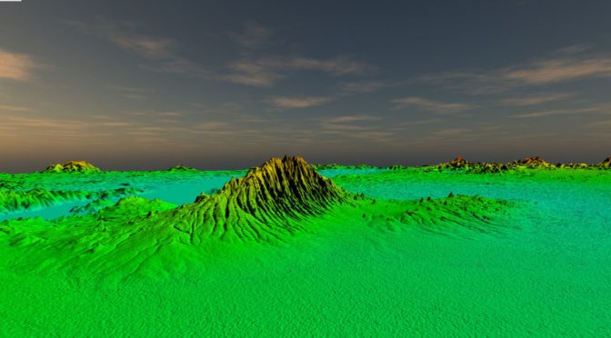
The Enable Hill Shading feature was enabled. Shading uses light direction and shadows to emphasize the topography of a terrain, creating a 3D effect that visually allows a researcher to see how flat or hilly a region is. Global Mapper has options with dynamic variables to manipulate the direction of the light and the darkness of shadows. For our model, these options were left at default with light direction at altitude 45°, azimuth 45°.

Shaded relief is often colored. It’s a method to represent topography in a natural, aesthetic, and intuitive manner. There are many philosophies and techniques of using colors in topography. For example, a researcher creating a topographic map of a dense vegetated Amazonian region may want to use different shades of greens to differentiate botanical life, or a terrain analyst may want to create a theme of brown colors of their arid, mountainous site. The researcher can also artistically represent the topographic regions with the colors that are pleasing to them. Global Mapper has a variety of options to create custom color schemes, modify values of slope colors, or import palette files of different formats. Global Mapper has 10 color presets for shaded relief. For our model, no custom color or modifying of existing color occurred. I used 3 pre-defined stock color presets to create 3 DEMs: Atlas Shader, Global Shader, and Slope Shader.

Our color shaders result in hypsometric DEMs using the Atlas and Global shaders. It represents the elevation of the terrain with the applicable colors in gradient intervals. An Elevation Legend and Distance Scale were added to DEMs from Global Mapper’s Configuration tool. The Slope Shader based DEM has a Slope Degree legend. Legends and scales were set at 75% transparency.

3 high-resolution PDFs and 3 high-resolution JPGs were exported from Global Mapper using Atlas, Global, and Slope shaders (see Figures 1-4). Due to the rise of using Google Earth for geological applications, I decided to also export 3 high-resolution KMZ files. KMZs are Google’s Keyhole Markup Language (KML) file format that are compressed. KML/KMZ is a language that’s focused on geographic visualization and the annotation of its images and maps. The small-scale image depictions of the actual JPGs and PDFs on this article make it difficult for the viewer to appreciate the scale of detail contained. Figures 5 & 6 contains zoomed regions in an attempt for the reader to understand its scale of detail. (A list of all exported files are found at the end of this blog post.)

Below are the exported KMZ files added to Google Earth Pro.

DEM Applications

DEMs are useful in examining the sand grain mineralogy distribution to topography, hydrological flows, and to study the influence of geological structures and tectonic processes on geomorphology. Active tectonics can also produce dynamic landscapes rich in geomorphological features that may play a crucial role in long-term patterns of hominid land use and the application of satellite-derived DEMs are useful for analyses.

Image from Winder et al. 2013. The Complex Topography hypothesis, or “Scrambler Man”

A multitude of other research postulates the correlation of land features to hominid evolution events. One research puts forth the Scrambler Man” hypothesis. The argument is that the use of rugged topography by early hominins to monitor and hunt mammals would have selected for transition to an upright posture, greater speed, and agility over time. The application of DEMs might be valuable to flesh out this hypothesis and possibly correlate applicable hominin features in other rugged landscapes.

DEMs are used in the reconstruction of paleo-elevations. Constructed DEMs interpolated from satellite data can be used with modern geological data collected by researchers to work backwards to produce paleo-digital elevation models. Not only could paleo-DEMs be useful to understand ancient surface processes, but can be applied to other hominid-landscape research, such as the “Scrambler Man” hypothesis. Paleo-DEMs were invaluable to reconstruct and simulate historical tsunamis.

DEMs are also useful for topographical archaeological surveys and other archaeological applications, that if interpolated with care, it can be used in GIS for effective predication of site locations. A DEM can be analyzed to create elevation profiles and to examine the link of geomorphologies to structures which can then be plotted against existing archaeological data.

3D printed DEM from Hasiuk & Harding, 2016

An interesting application is the 3D printing of DEM data. It can be a geological teaching tool to help students with conceptual difficulties and enhance the 3D problem-solving skills of many geologists. A small-scale 3D printed DEM may prove useful at the research site for survey planning.

It is my opinion that the noted DEM applications can be of value to the rich ongoing fieldwork at the Turkana Basin.

Summary and Future Directions

The collecting of SRTM data and interpolating it into DEMs of the Turkana Basin via Global Mapper was successful. Because of the long periods of processing and resulting file sizes, it would be ideal to interpolate SRTM data to DEM on smaller, unique regions that are of primary interest to the researcher. This will allow exporting at maximum resolutions while reducing file size footprints.

I wish to create DEMs from ASTER satellite data and compare it to the SRTM DEMs via layers in Global Mapper. Further exploiting the terrain analyses tools of Global Mapper will be of use for in-depth analysis of DEMs (see following images).

3D view in Global Mapper from DEM interpolated from SRTM Data
3D view with generated contour lines overlayed on the DEM
A vertical elevation profile generated in Global Mapper using the line draw tool. The red line on top is a Cut-and-Fill feature designed to summarize the areas and volumes of change. This feature if used with satellite derived DEMS from different points in time, will allow the identification and analyses of surface material removed, surface material addtion, and areas that are unchanged
Zoomed section of DEM terrain layered with generated contour lines
Watershed analysis via Global Mapper
Generated contours from DEM via Global Mapper
Random 3D view of Turkana Basin Terrain
Turkana Basin 3D view in Wiremode

All relevant files used and exported for this DEM project are listed below. All files are found on a shared folder via my Google Drive.

Remembering Hatuey and the Tainos

The evening was crisp. Cold Malta Hatueys were bountiful at a recent family gathering. As I imbibed one under the tranquil shade of a willow-like tree, its label transfixed me. I slumbered off into childhood memories of the drink. Ahh, mí abuelita (my grandmother). I can still recall the warmth of her gentle smile as she handed me Malta Hatuey. They were tasty rewards for helping her with errands, like running to the local bodega to purchase Puss’n Boots catfood for her overlyprotective cat Mauricio and votive candles. A continuously lit candle adorned the religious shrine that rested on her bedroom’s dresser, brimmed with religious artifacts from rosarios to miniature statutes of La Virgen She prayed for hours to keep all of the family and the world safe.  It was considered a bad omen if a candle wasn’t perpetually lit on her dresser-shrine, as if the extinguishing of its light would allow vile darkness to permeate into our world.

A 1970s photo of mi abuelita holding my cousin in the barrios of Newark, NJ. She was a strong woman, both physically and in heart, up to her death of 91.

After remembering my abuelita’s spiritual reflections, I reflected on the bottle of Malta Hatuey in my hand. It’s a sweetened malt beverage of hops and molasses. They are iconic in the Latino community. As a child, I thought the Indian guy depicted on the bottle was the Spanish version of the Lone Ranger’s sidekick, Tonto. Throughout the adolescent years, I learned that Hatuey was a real indigenous chief of our ancestors, the Taínos.

A bottle of Malta Hatuey in my hand.

The Taínos are the indigenous people that collectively inhabited the Caribbean islands (Puerto Rico, Bahamas, Dominican Republic, etc) for hundreds of centuries.

gfgf fgfg fgfg f gff
Map showing the regions of Taino people across the Caribbeans.

They were skilled agriculturalists who farmed beans, peppers, corn, yams, and Yuca, a tuber plant that is the source of tapioca, farina, and cassava flour to create breads. As powerful seafarers who built grand canoes, they supplemented their diets with fish and crabs – even eating some of the eggs laid by visiting sea turtles. Taínos lived in huts constructed from local trees and plant life. They learned how to process the sap of the rubber tree, creating waterproof shoes and ponchos. They created a heavy rubber ball used for a sport, Batey, played on a clay court where two teams (10-30 players per team) would keep it in the air by bouncing the ball with their hips, heads, arms, and legs (no hands). They cultivated cotton to create hammocks and fishing nets. Dance and the sound of drums and maracas pulsated daily life while being enveloped with pristine beaches, caressing winds, tropical weather, and green mountainous landscapes. They were peaceful islanders who were one with nature.

A European artist’s depiction of Taíno fishermen. Woodcut from Girolamo Benzoni’s “Historia del Mondo Nuovo,” Venice, 1563.

They were also the first people to greet Columbus. Upon his 1492 arrival, the Taínos greeted and fed them. Columbus noted in his diary that the Taínos were peaceful and beautiful masculine people who would make great slaves. Ultimately, that was the prophetic fate for the Taínos: they were enslaved and forced to work in mines to extract gold for Columbus and his entourage. Bartolome de las Casas–one of the many priests brought in by Columbus–would later write that Columbus’ men made them perform “…tasks utterly beyond their strength, bending them to the earth with crushing burdens, harnessing them to loads which they could not drag, and with fiendish sport and mockery, chopping off their hands and feet, mutilating their bodies in ways which will not bear description.”

A depiction of Christopher Columbus encountering Tainos. An engraving ca. 1594 by Theodor de Bry. It’s important to note that practically every early painting and illustration of Tainos do not reflect them accurately. They are merely artist depictions.

Bartolome was a priest who supported the colonization of the Caribbeans, but after observing the monstrosities inflicted upon the Taínos, he changed his views. Bartolome believed that altruism and spreading the word of God was no longer a driving force in Columbus’ expeditions, but a ruse to fuel the unquenchable appetite for power and gold. He wrote a series of works in the 1550s that outlined the plethora of horrors suffered by the Taínos. He wrote that Columbus’ men would “… breed fierce hunting dogs that would devour an Indian like a hog, at first sight in less than a moment.” Repeated throughout his work are the use of dogs against the Taínos, writing that they purposely kept them hungry to make them more violent. The flesh of Taínos were fed to them as if to teach them to love their meat.

An early artist’s depiction of Columbus’ dogs feasting on Tainos.

These stories became commonplace as Columbus’ men encountered new villages while venturing deep into the wombs of the islands. One village of 2,500 Taínos welcomed them, filling their tummies with foods and drinks. Once the feast was over, Columbus’ men turned against them: slashing, disemboweling, and slaughtering them until their blood flowed like a seething river. As Columbus’ men increasingly colonized the islands, their barbarousness deepened. They would bash Taíno babies against rocks or throw them into rivers. They hanged Taínos in groups of 13 and burned them alive – in memory of Jesus and the 12 apostles. For fun, Columbus’ men challenged each other on their skill of cleanly chopping a Taíno’s head off or chopping them vertically in half in one blow of the sword. In their off time, the rape of Taíno women and young girls was an everyday occurrence. Taíno children young as 9 were sold into the sex trade.

An illustration used in Bartolome de las Casas book depicting the burning of Tainos and a Taino child about to smashed against a wall.

The Taínos did not know what was wrong with these foreign guests. They thought that they were mad men who became crazy at the sight of gold. Columbus demanded quotas of gold from each Taíno man 12 and older. When they weren’t met, Columbus’ men would simply chop off their hands. Many Taíno men died within months of working in mines due to overexertion and extreme malnourishment. Infants died due to lack of milk. Since parents could no longer attend to their crops, thousands of children would die of hunger. Many Taínos would commit suicide instead of becoming slaves. Some would even kill their own children to spare them from the inevitable horrors that awaited their futures.

An artist’s depiction of Columbus’ men chopping off the hands from Taínos for not bringing enough gold. Dogs are feasting on Taínos in the background. Note how some are shown with mutilated noses; this was a common practice, particularly against Taíno women.

Escapees would spread stories of the wild atrocities committed by the bearded men who arrived on giant boats from across the oceans. Hatuey was a Taíno cacique (chief) on a distant part of the Islands. When stories of carnage made it to Hatuey, he promptly witnessed the advancing terror to surrounding yucayeques (villages). Hatuey left with about 400 men, women, and children on a fleet of large canoes. He wanted not only to save his people, but to warn others of the impending doom with the hopes of raising an army to stop them. Hatuey would display a basket of gold to other villages and argued:

“Here is the God these crazy bearded men worship. They kill us and persecute us because of this metal…and this is why we have to throw it all into the sea. These tyrants tell us they adore a God of peace and tranquility, but yet they take our lands and make us their slaves. They speak to us of an immortal soul and of their eternal rewards, but yet they rob our belongings, rape and violate our women and daughters. These cowards cover themselves in iron that our weapons cannot break.”

An artist depiction used in a version of Bartolome de las Casas book illustrating the massacre of Anacaona (a Taína chief) and her people by Columbus’ men.

Some simply didn’t believe Hatuey, since the stories seemed too fanciful. Some did and Hatuey managed to form a small resistance. His army was successful in killing a few of Columbus’ men, giving inspiration to those enslaved. This resulted in severe, grotesque retaliation, with Taínos being tortured to death for information of Hatuey’s whereabouts. After many months of agony, Hatuey and some of his army were captured.

To be made an example of, Hatuey was tied to a stake for a public execution. Before Columbus’ men set fire, a priest explained the concepts of hell and Christianity to save his soul so that he can repent and go to heaven. Hatuey asked the priest, “Will I be in this heaven that you speak of with all of your Christian soldiers?” to which the priest responded “Yes.” Hatuey eyeballed him with scorn and said, “I would rather go to hell, instead of a place with such cruel people.” Oral histories tell us that Hatuey yelled words of freedom and rebellion against the Columbus’ people before the storming fire deafened his last words.

An illustration used in Bartolome’s book showing Hatuey being burned at the stake.

The combination of diseases (e.g. measles and influenza) and genocides introduced by Columbus’ men, resulted in the extinction of the Taínos – rather, that is what the general public has been led to believe for centuries. The notion of Taíno extinction has been promoted by many American authorities, anthropologists, and other scholars.  This posed massive disadvantages to cultural identities. One only has to glimpse at the long dark history of U.S. treatment towards Native Americans; they essentially destroyed their cultures, justified its actions, then attempt to create an American narrative about their histories – despite that the Natives are still a living culture.

There has been an enduring, muzzled fracas among Caribbean cultures and western scholars. Many Caribbean leaders argue their indigenous heritage, that countless Taínos survived the Columbus era and are still alive today. Western scholars stridently say no, hammering into them that the Taínos are wholly extinct.  Anthropologist Maximilian Forte argued at a Cambridge conference that this theme of Taíno extinction in scholarly literature is a motivated narrative for assimilationist discourse,  ideological narrative of western progress of “weaker” people giving up traditions to “stronger” modern ones, symbolic advantages, and for political economic and material advantages. Jorge Estevez, a Taíno project member at the National Museum of the American Indian, said:

“Paper genocide” practiced by historians ever since, has been just as cruel on my people. With the stroke of their pens, the legacy of my ancestors was wiped out.”

A stamp from my collection of Bartolome de Las Casas. Mexico and other Latin América countries honor him as a man who stood up for the indigenous peoples.

The seeds of the Taíno extinction narrative can be traced back to the very people that exploited the Taínos. Spaniard priests that settled in the Caribbeans led a campaign that intentionally over-emphasized the decline of Taíno people to an  80-90% loss due to extreme labor, disease, and physical punishment.  Ironically, this campaign was led by Bartolome de las Casas. This exaggerated narrative was a method for the priests to convince their government to abolish the Encomienda System and to replace it with a missionary system for Taínos. The Encomienda was a bizarre legal economic system that allowed slavery of the Taínos, where their owners had to evangelize and “protect” them in return for their (labor) services,  but that the Taínos had to pay “tribute” to their protectors in the form of gold, foods, and other materials.  The priests believed that by lying about their decline, it would literally save the Taínos. This campaign contributed to changes, particularly the 1512 Leyes de Burgos, which were the first set of laws to cull the ghastly behaviors of its people against the Taínos. It’s 39 laws consisted of stuff such as:

• For every 50 Taínos, 4 lodges must be built (12-13 Taínos crammed into one 30×15′ unit).
• Whoever owns 50 Taínos, one boy must be chosen to teach them reading, writing, and Catholicism. This law was more of a brainwashing/assimilation schema: “This boy will then teach the other Indians because the Indians would more readily accept what the boy says than what the Spaniards says…The faith must be ingrained into their heads so the souls of the Indians are saved.”
• You can no longer physically or verbally abuse Taínos for any reason.
Don’t let Taínos sleep on the ground; you must provide hammocks (Although Taínos invented them, they were deprived of hammocks).
• You must build churches near mines so that Taínos working on Sundays can hear mass.
• You must feed the Taínos foods (peppers, yams, breads) and one weekly cooked meat meal. If you don’t, you will be fined 2 gold pesos.
• If you own a Taíno, you must give them 1 gold peso every year (so that they can pay for their own clothing!).

However well-intended Bartolome’s campaign may have been, others began to selfishly capitalize from it, by repeating the (false) significant decline of the Taínos put forth by his campaign. This allowed for many Taíno slave owners to exaggerate their slave losses in order to gain sympathy and persuade their government for permission to import more African slaves (African slaves were high in demand, because they were stronger and more immune to diseases than Taínos). This doesn’t include the census problem that later trickled into scholarly literature. Many scholars argue that this period kept detailed records, but their censuses generally accounted for Taínos who were kept as slaves in the Encomienda system. It excludes the countless Taínos and imported African slaves who escaped into the depths of Caribbean mountains and forests. This is even documented by military leader Nicolás de Ovando in 1502, writing that Africans escaped with Taínos very often, using the Taínos’ knowledge of the lands to evade slavery. Lynne Guitar, a retired Caribbean anthropologist, argued that these censuses are misleading and unreliable, noting that:

“How can you pretend to count people for a census who are hiding from you?”

Genetic sciences have been catching up, providing the scientific gravitas that has been building a framework of evidence that Taíno ancestry survived to modern day.  The work of a Stanford geneticist was published via Nature that discussed the results of his 1000 Genomes project that sought to reconstruct the genetic variation of indigenous descendants. He found that the people of Puerto Rico has an average of 10-15% Native DNA that is largely Taíno. When discussing the results, Nature added their own thoughts that the Taínos are extinct, but immediately issued a correction:

“This article originally stated that the Taíno were extinct, which is incorrect. Nature apologizes for the offence caused, and has corrected the text to better explain the research project described.”

Nature‘s apologetic-correction has angered some anthropologists and other scholars because they agreed with Nature‘s initial stance, that the Taínos are extinct. Some even argued that the correction show how timorous contemporary scientific culture has evolved. Regardless of the persistent Taíno extinction narrative, other studies keep mounting. Dr. Juan Cruzado,  a Harvard biologist, conducted an island-wide study by testing the DNA of 800 randomly selected islanders and found 61% had mitochondrial DNA of the original indigenous population. A team of 7 biologists conducted a similar study in Cuba, finding a high rate 33% of maternal Native DNA among their sample of 245 unrelated individuals. A team of 21 scientists published the results of a Caribbean-wide genomic study that show indigenous ancestry and its correlation with linguistic and archaeological evidence. While there are many more similar studies, a paramount study by 27 scientists was published in 2018 via Proceedings of the National Academy of Sciences entitled “Origins and Genetic Legacies of the Caribbean Taino.” Their research is based off prehistoric skeletons that were excavated in 2007 from Preacher’s Cave in the Bahamas. They lived some 500 years before Columbus’ journey into the New World and the radiocarbon dated thousand-year-old remains provided the tangible evidence that allowed scientists to implement a relatively new science tool: aDNA, or Ancient DNA.

A Taino mandible excavated from Preacher’s Cave, Bahamas.

Ancient DNA is a method that allows for the extraction of DNA from prehistoric skeletal remains of deceased individuals. From this, scientists can sequence its genome. What all this mean in layman’s terms, is that a person’s DNA can store a ‘book’ full of chapters that tell the historical stories about one’s DNA journey. These stories are written in biological code that our computers can translate. A computer can then take the stories from that one book and compare it to the stories of other books–libraries of other DNAs–informing us of interesting insights, such as migration patterns.  Despite the field of ancient DNA changing our views of the past, there’s a subtle uneasy relationship between archaeology and ancient DNA and a concern for its potential abuse.

One archaeologist, Dr. Phillip Stockhammer quipped:

“Half the archaeologists think ancient DNA can solve everything. The other half think ancient DNA is the devil’s work.”

Stockhammer’s witty remark implies a mild dilemma among some scientists: reluctance to change. Although science is our best tool, its operators are humans. There are many scholars who have built careers on sculpting certain neat narratives that become reinforced by circles in their disciplines. Sadly, their egos will bark when new research or technologies threaten their established territories.  Often, a stranglehold is placed on scientific progress when scholars become gladiators, quarreling that the other is wrong. These stories abound in the history of science, like the stories of Einstein, Alfred Wegener, and Michael Faraday. But that’s another matter, perhaps for a future blog post.  Let’s go back to the 2018 study by 27 scientists. What is most significant about this study, is that it provides the first clear evidence of genetic continuity of Taínos in a modern Caribbean population based on an ancient genome. When comparing the ancient genome to a sample of 104 living Puerto Ricans, they found that 10-15% of their indigenous ancestry are similar to the Taínos than any other indigenous group. The study provides conclusive proof that Taíno indigenous ancestry has survived to modern day. It’s important to note that these findings are unlikely to be exclusive to Puerto Ricans, as future studies will likely reveal Taíno genetic legacies in other Caribbean communities. Dr. Hannes Schroeder, a molecular anthropologist, bioarchaeologist, and lead scientist of the study stated:


“It’s a fascinating finding. Many history books will tell you that the indigenous population of the Caribbean was all but wiped out, but people who self-identify as Taíno have always argued for continuity. Now we know they were right all along: there has been some form of genetic continuity in the Caribbean.”

Elsewhere, Jada Benn Torres, a genetic anthropologist, stated:

“These indigenous communities were written out of history. They are adamant about their continuous existence that they’ve always been on these islands. So to see it reflected in the ancient DNA, it’s great.”


What does all of this intimately mean for the Caribbean peoples, or at least to the people of Puerto Rico? Practically nothing.  While the ancient DNA study might be liberating and uplifting to some, the majority don’t care about what science and other authorities inform them about their culture. Many people on the island have long identified with their Taíno roots, particularly those that live in countrysides and mountainous regions. Generation after generation, the stories of their indigenous ancestors has been orally transmitted, along with the agricultural knowledge and other cultural aspects that are still practiced today. Many of them see the works of science and historians that concerns their histories as a pseudo-sophisticated game where its players have something to argue about, receive trivial awards for constructing false narratives, and collect dishonorable income. My heart sympathizes with them, as Puerto Rico has endured a long, arduous history of oppression at the expense of others. When Spain’s government abolished slavery in 1873, a patchwork of pernicious acts continued in Puerto Rico for the next century, notably those levied by the United States of America. Some examples:

• The decades-long forced sterilization practices by the U.S that resulted in over 35% of Puerto Rico’s women inability to have children. This was motivated by U.S. eugenics.

• The U.S. Navy using Vieques as a bombing range for decades, leading to over 20 million pounds of military waste that has leached in the local ecology, desecrating and causing mutations among wildlife, and placing Vieques as the site of the highest rates of cancer and illnesses in Puerto Rico. Clean up efforts still continue to this day.

• The exploitation of poor, uneducated Puerto Rican women in a large-scale birth control pill trial under misleading information.

• The United States FBI creating secret files on over 100,000 Puerto Ricans from 1930s to 1990s in an attempt to curb political dissent against the U.S., largely aimed at people who were fighting for independence. These files contained information of a personal nature, from names of sexual partners, copies of personal letters (intercepted at the postal office), to laundry tickets.  These files were not only used politically to deny work and educational opportunities, but to also imprison, fire, and discredit Puerto Ricans. PR was an island of happy, gregarious, and open people, but after 60 years of U.S. spying and informants, it affected the national character of Puerto Rico by etching fear, lying, betrayal, secrecy, and mistrust into its sociological atmosphere. In 2000, the FBI director admitted that “the FBI did operate a program that did tremendous destruction to many people” and to the island of Puerto Rico.

• A few others include an American doctor injecting cancer cells into Puerto Ricans, radiation experiments, and robber barons who ravaged the native agriculture to turn PR into a cane sugar producing machine for America.

Throughout much of our world history, the cycle of subversion seem to sing the same lyrics: We’ll exploit and destroy everything  now, then we’ll issue a whitewashed-apology later on. The U.S. Navy has admitted in dumping toxic chemicals like uranium and Agent Orange in Vieques Puerto Rico, but whitewashed that their operations has no correlation to the illnesses that afflict the inhabitants to this day. We’re straying off topic, but hopefully one can understand that the decades of wretchedness cultivated distrust in the hearts of many Puerto Ricans, leading them to loath competing narratives put forth by authorities that attempt to educate them on their own Taíno culture.

A modern artist’s painting depicting Tainos and their petroglyphs.

For the majority of the world, the Taínos are long forgotten. They do not receive much press like the Mayans or Incans. The Taínos did not create grand structures or even have a written language. Their ‘language’ was in the form of petroglyphs and art, which can be found in limited books on Taíno art, Caribbean archaeological books and select museums, like the Met Museum in NY.

Archaeologist Hernan Bustelo observe Taino petroglyphs in Ponce, Puerto Rico.

Today, there are statues of Hatuey and of other Taínos around the Caribbeans. Locally, Hatuey is forged as the first freedom fighter of the Americas.

The memory of the Taínos are preserved by holding periodic Taíno celebrations, local cities and towns maintaining their Taíno names, naming of local structures & organizations (such as an agricultural science research station) in Taíno, and in local products and consumables, like Malta Hatuey.  History is important because it allows one to understand circumstances that create change over time, however admirable or malevolent. Taíno history is important to remember because it’s part of the indigenous ancestry of modern Caribbean cultures and for the rest of the world: a lesson of the horrible, complicit circumstances that contributed to their decline. My grandmother’s ritual of lighting a candle is relatively metaphorical: We keep the history of our ancestors “lit” in our hearts, to ensure that the vile darkness never repeats itself again.

-antonio